Why use GLOBIO?
A short history of the GLOBIO model
The first version of the GLOBIO model was developed around the turn of the millennium, within the UN’s Environment Programme. It was designed to assess potential impacts of roads and other infrastructure on biodiversity. Depending on the distance to the nearest road, the model delineated different impact zones depending on the expected influence on animals and plants.

In 2002, the Conference of the Parties of the Convention on Biological Diversity (CBD) agreed to achieve a significant reduction in the rate of biodiversity loss, from global to national levels, by 2010. To meet the challenge of evaluating this CBD target, an international consortium consisting of the UNEP World Conservation Monitoring Centre (WCMC), UNEP GRID-Arendal and PBL Netherlands Environmental Assessment Agency set out to extend and improve the GLOBIO model. More human pressures beyond roads were added, as well as a more quantitative metric of biodiversity: the Mean Species Abundance (MSA) indicator. MSA was built upon the Natural Capital Index (NCI) research, which was developed at the Dutch National Institute for Public Health and the Environment (RIVM) and published in the UNEP Global Environment Outlook 3.
These efforts resulted in the GLOBIO3 model (first published in 2009), including four human pressures (land use, climate change, atmospheric nitrogen deposition and infrastructure) and using the MSA metric to quantify biodiversity intactness. Over the past years, the model was further improved and refined to GLOBIO 4 (first published in 2020), which runs at a much higher spatial resolution and contains new modules for downscaling land use and for quantifying impacts of hunting in the tropics. Over the past years, GLOBIO has been extensively used in various environmental outlook studies, for example for the Convention on Biological Diversity (CBD), the Global Environmental Outlook (GEO) of UNEP and for the assessments of the Intergovernmental Science-Policy Platform on Biodiversity and Ecosystem Services (IPBES).
Meanwhile, various extensions of GLOBIO were developed to cover additional relevant aspects of nature. The GLOBIO-ES model has been developed in order to capture the benefits that people obtain from nature, for example through the provisioning of food and drinking water, and the regulation of climate and soil quality. The GLOBIO-Aquatic model was developed to cover freshwater ecosystems, which host unique biodiversity and provide essential ecosystem services yet are degrading at even higher rates than terrestrial habitats. GLOBIO-Species is the most recent member of the GLOBIO model family, designed to quantify multi-species biodiversity indicators based on changes in the distribution and abundance of individual vertebrate species.
Scenarios of biodiversity and ecosystem services
GLOBIO is regularly used in (global) environmental and biodiversity outlook studies, for example for the Convention on Biological Diversity (CBD), the Global Environment Outlook (GEO) of UN Environment, and for the assessments of the Intergovernmental Science-Policy Platform on Biodiversity and Ecosystem Services (IPBES). Applications include exploratory scenarios, which examine ranges of possible futures, as well as intervention scenarios, which seek to evaluate the effects of possible policy interventions and solution-oriented scenarios that assess pathways to meet specific (internationally agreed) biodiversity goals.
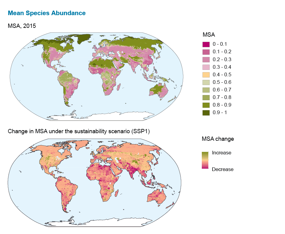
An example of an exploratory scenario study is the application of GLOBIO to assess the consequences of three of the Shared Socio-economic Pathways (SSPs) for terrestrial biodiversity intactness. In this study, GLOBIO was used to project terrestrial biodiversity intactness from 2015 to 2050 as a function of changes in land use and climate corresponding with three diverging SSPs. We found that biodiversity declined in all three scenarios, albeit declines were smaller in the sustainability scenario (SSP1).

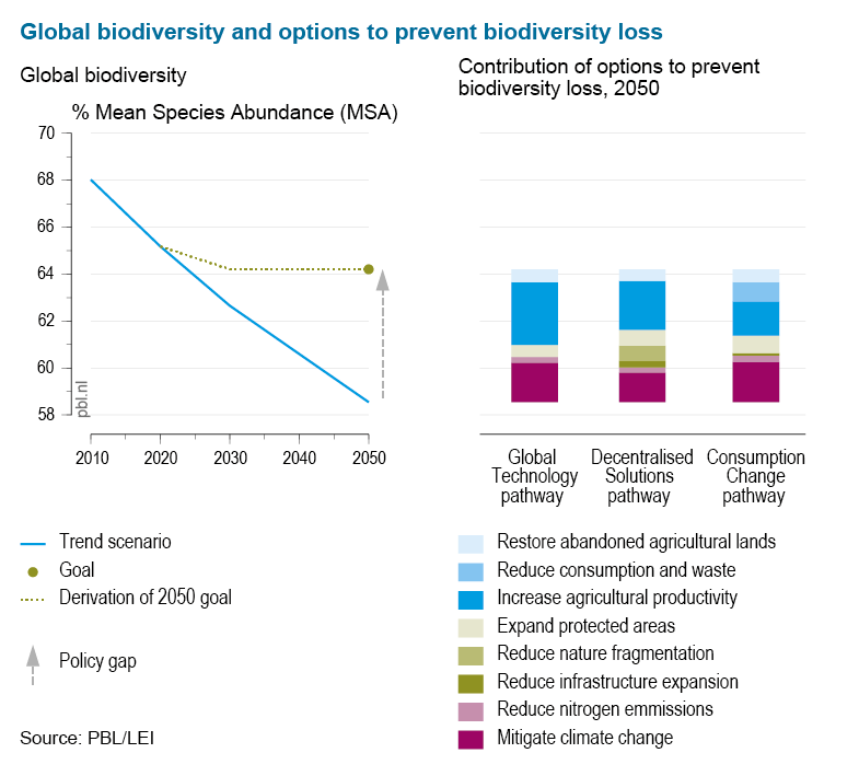
In another outlook study contributing to the CBD Global Biodiversity Outlook 4, GLOBIO was used to assess the environmental benefits of three sustainable development strategies: Global Technology, Decentralised Solutions, and Consumption Change (as illustrated in the figure). Each of these pathways pursued international biodiversity goals together with a broader set of environmental sustainability objectives (for example, feeding the world, universal access to modern energy, limiting climate change and controlling air pollution). IMAGE-GLOBIO was used to evaluate these scenarios up to 2050, which showed that various combinations of production- and consumption-based measures and ecosystem management changes can substantially reduce biodiversity loss globally.

In the European OpenNESS project, intervention scenarios were developed to assess the consequences for biodiversity and ecosystem services (BES) of four socio-environmental scenarios designed from a nature-centered perspective. Simulations with IMAGE-GLOBIO and the integrated assessment platform CLIMSAVE revealed that none of the four scenarios achieved an overall preservation of BES in Europe, yet that targeted policies (e.g. on climate change, biodiversity conservation and sustainable land management) and societal behavioural change (e.g. reduce meat consumption, water saving behaviour) reduce the magnitude of BES loss.
Supply-chain accounting
Effective strategies for halting or reversing losses of biodiversity and deterioration of ecosystems need to consider that the losses in a given region or country might be driven by production or consumption elsewhere, as the world is increasingly connected via international trade flows. Insights in supply-chain-related biodiversity losses, also called biodiversity footprints, offer promising starting points for policy makers to reduce global biodiversity loss via measures that target consumption or trade. Furthermore, insights in biodiversity footprints of economic sectors can be used by policy makers or sector organizations to develop and prioritize strategies to reduce direct and indirect (i.e., upstream in the supply chain) biodiversity losses.
GLOBIO can be used for quantifying biodiversity footprints by connecting changes in biodiversity to environmental pressures (for example, climate change or land use) that are associated with the production of goods or the delivery of societal services (for example, transport) in specific countries or regions. In turn, the biodiversity changes induced by production can be linked up with the consumption (final demand) in countries and regions across the globe based on international trade data.
![]() Link to paper Biodiversity footprints of nations
Link to paper Biodiversity footprints of nations
![]() Link to paper Biodiversity footprints of (Dutch) economic sectors
Link to paper Biodiversity footprints of (Dutch) economic sectors
Landscape planning
Inclusive and participatory spatial planning and land governance are becoming more and more important, as cumulative pressures from the demands for urban expansion, the production of food, feed and bio-fuels, and nature conservation lead to increasing competition for natural resources. This also has an impact on the flows of ecosystem services. The landscape is increasingly seen as the level on which these current and future global challenges converge. As a socio-ecological system that is organised around a distinct ecological, historical, economic and socio-cultural identity, the landscape is also the spatial scale on which many different stakeholders, from global to local, need to find ways to cooperate.
In the context of achieving the globally adopted Sustainable Development Goals, local balancing of competing interests, sharing of benefits and mitigating perceived collective risks are prerequisites to solving complex nexus challenges. Integrated Landscape Management (ILM) is a way of managing a landscape that involves local, regional and sometimes even international stakeholders, like for instance farmers, businesses, NGOs, indigenous communities and various types of government organisations. Together, the stakeholders agree on a shared vision that aims at achieving multiple goals on for instance food, water, climate and biodiversity simultaneously.
An effective ILM process can create an improved understanding among stakeholders of the conditions and dynamics in a landscape. It thereby also supports mainstreaming of biodiversity and ecosystem services. Mainstreaming aims to reduce the impacts that productive sectors, development investments and other human activities exert on biodiversity and ecosystem services.
Thanks to its flexible and modular set-up, GLOBIO can also be applied at sub-national to national scales, for example to identify and evaluate policy options at landscape scale. Best-available local spatial data can also easily be implemented, to better reflect specific landscape contexts. Over the past years, GLOBIO has been extensively applied in national and regional studies. In a recent example GLOBIO was used in a PBL project that focused on spatial modelling of participatory developed scenarios. The outcomes supported discussions and landscape planning in multi-stakeholder initiatives in Ghana, Tanzania and Honduras.

